Back Thetford Mines Afrikaans ثيتفورد ماينز (كيبك) Arabic Thetford Mines ATJ Thetford Mines CEB Thetford Mines English Thetford Mines Spanish Thetford Mines Estonian Thetford Mines (Quebec) Basque تدفورد مین Persian Thetford Mines French
| Thetford Mines | ||
|---|---|---|
 Stadtzentrum von Thetford Mines | ||
 Wappen |
||
| Lage in Québec | ||
| Staat: | ||
| Provinz: | Québec | |
| Région administrative: | Chaudière-Appalaches | |
| MRC oder Äquivalent: | Les Appalaches | |
| Koordinaten: | 46° 6′ N, 71° 19′ W | |
| Höhe: | 332 m | |
| Fläche: | 226,32 km² | |
| Einwohner: | 25.403 (Stand: 2016[1]) | |
| Bevölkerungsdichte: | 112,2 Einw./km² | |
| Zeitzone: | Eastern Time (UTC−5) | |
| Gemeindenummer: | 31084 | |
| Postleitzahl: | G6G | |
| Vorwahl: | +1 418 | |
| Bürgermeister: | Marc-Alexandre Brousseau | |
| Website: | www.ville.thetfordmines.qc.ca | |
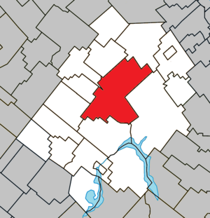
 Lage in der MRC Les Appalaches | ||
Thetford Mines ist eine Stadt im Süden der kanadischen Provinz Québec. Sie liegt in der Verwaltungsregion Chaudière-Appalaches, je rund 100 km südwestlich der Provinzhauptstadt Québec und nordöstlich von Sherbrooke. Thetford Mines ist der Verwaltungssitz der regionalen Grafschaftsgemeinde (municipalité régionale du comté) Les Appalaches, hat eine Fläche von 226,32 km² und zählt 25.403 Einwohner (Stand: 2016).
- ↑ Statistics Canada: Census Profile, 2016 Census – Thetford Mines, Ville (Census subdivision), Quebec and Quebec (Province), abgerufen am 3. Juni 2021
